New Study: Larger, More Intense U.S. Storm Complexes on the Way

Above: This infrared satellite image shows a massive mesoscale convective complex across parts of Nebraska, Iowa, and South Dakota on August 8, 2010 at 6:58 p.m. CDT. The orange colors denote very cold cloud tops, a sign of intense updrafts producing very heavy precipitation. The coldest temperature indicated is –91°C (–132°F) near the center of the storm complex. Image credit: UW-CIMSS, via weather.com.
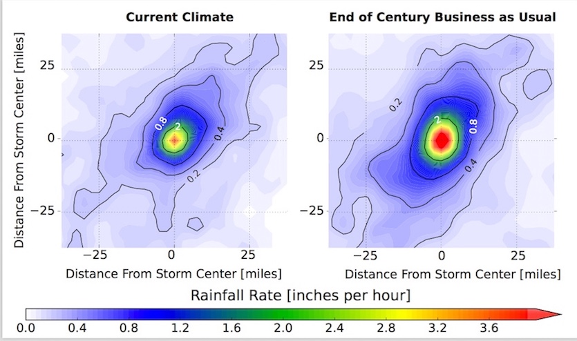
The mammoth clusters of thunderstorms known as mesoscale convective systems (MCSs) could dump up to 80% more water across North America by late this century, according to a study published Monday in Nature Climate Change. The study, “Increased rainfall volume from future convective storms in the U.S.,” found that increased atmospheric moisture in a warming climate will help lead to a 15 – 40% increase in peak MCS rainfall rates, along with a 20 – 70% jump in the rainfall area. Together, these lead to a 30 – 80% boost in the total hourly volume of rain deposited by a typical MCS.
"The combination of more intense rainfall and the spreading of heavy rainfall over larger areas means that we will face a higher flood risk than previously predicted," said the study team, led by Andreas Prein (National Center for Atmospheric Research). “Current investments in long-lived infrastructures, such as flood protection and water management systems, need to take these changes into account to improve climate adaptation practices.”
The study used a high-resolution computer model to simulate MCS behavior within the climate of the recent past (2000-2013) and for the late 21st century (2071-2100). The latter was based on “business as usual” greenhouse gas emissions this century—the RCP8.5 pathway developed for the Intergovernmental Panel on Climate Change.

Getting a handle on the character of tomorrow’s heavy rain
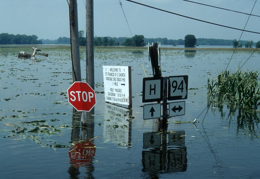
Numerous studies have shown that the most intense rain events in many parts of the world, including the United States, are getting heavier, as human-produced greenhouse gases warm our climate and send more moisture from oceans into the atmosphere. The new study zeroes in on a storm type notorious for its flood risk. MCSs can occur in sequences that last for weeks, sometimes leading to disasters such as the epochal Missouri/Mississippi River floods of 1993, the most damaging fresh-water flood event in U.S. history, and the Texas/Oklahoma floods of May 2015. MCS processes can also become important after hurricanes or tropical storms make landfall, such as during the record-smashing rains of Hurricane Harvey in August 2017.
In this study, MCSs are projected to become wetter and larger across all seven North American regions outlined by the authors (including Canada, Mexico, and five U.S. regions). MCSs also become more frequent in all regions except the central U.S, with the biggest percentage increase in Canada and the northeast U.S. In those two regions, MCSs with peak rainfall rates of greater than 80 mm/hr (3.15” per hour) “are almost unrepresented in the current climate,” but they become frequent in the future, said the authors.
Changes in storm motion are more variable. Those MCSs that move at less than 12 mph could slow down by another 20% across large parts of the central and eastern U.S. However, MCSs could tend to speed up across parts of Mexico and the northeast U.S.
Summertime’s rain-making machines
On average, about 60 MCSs per year develop each summer across the central United States. MCSs can occur as squall lines or as huge circular clusters known as mesoscale convective complexes, with cloud tops covering an area more than 200 by 200 miles across. Many of these complexes intensify in the evening and grow to enormous size as they churn eastward overnight and into the next morning. Rather than being known for violent tornadoes or large hail, MCSs tend to produce high downburst winds (sometimes including derechos) and extremely heavy rain.
The resolution of standard weather and climate models is too coarse to track individual showers and thunderstorms (convection). The new study is one of the first to evaluate changes in the behavior of MCSs by using a convection-permitting model—in this case, a variant of the Weather Research and Forecasting model (WRF).
“Climate models that run at coarse resolution have struggled to simulate even the most basic characteristics of MCSs, such as how fast they move or what time of day they most frequently occur,” said Russ Schumacher, an MCS expert at Colorado State University, in an email. Today, he said, “increased computing power has started to make it possible to use the same models that we use for weather forecasts to also simulate possible future climate scenarios."
In this study, the WRF model grid points were separated by 4 km (2.5 miles), which is just dense enough to realistically capture many features of MCSs. The study employed a “pseudo–global warming” approach, a commonly used technique in which the atmospheric and oceanic conditions surrounding the North American study region were varied to represent the temperature and moisture values observed in recent climate and expected in the future.
The authors examined the 3-D characteristics of MCSs in both recent and future climates. Across the mid-Atlantic, for example, the average MCS late this century is projected to have cloud tops that are 1800 meters (5900 feet) higher and 3.8°C (6.8°F) colder than for present-day MCSs.
Overall, the future MCSs are able to draw on greater amount of convective available potential energy (CAPE), a measure of the contrast between warm, moist air at lower levels and cold, dry air at upper levels. The added moisture at low levels leads to greater instability and enables the future MCSs to extend to higher, colder altitudes. The heavier rainfall rates are facilitated by a deeper “warm rain” layer, with a freezing level that averages roughly 860 m (2820 ft) higher than at present.
A worrisome prognosis
“These new simulations of future MCS rainfall are concerning, because they show very large increases in the amount of rain that a given MCS is likely to produce,” said Schumacher, who was not part of the research team. “The MCSs that we would today consider to be ‘extreme’ in terms of precipitation would become more commonplace in the future. There are also some regions that currently don’t see a lot of MCS activity that might start seeing some of these heavily raining MCSs in the future.”
Schumacher noted that the pseudo–global-warming method used in this study does not account for potential changes in large-scale dynamics, such as the location of upper-level troughs and ridges. Still, he added, “the findings are in line with other studies that have used different methods, and the Prein et al. study also offers plausible physical reasoning for the modeled changes. I don’t think that this study, and its companion studies also published recently, give the last word on the subject of future precipitation changes, but they contribute to an important conversation on this worrisome topic.”
The new study was supported by the National Science Foundation and the U.S. Army Corps of Engineers. For more about MCSs, see this Severe Weather 101 website from the NOAA National Severe Storms Laboratory and this MCS explainer from weather.com.
The Weather Company’s primary journalistic mission is to report on breaking weather news, the environment and the importance of science to our lives. This story does not necessarily represent the position of our parent company, IBM.