Hurricanes, Typhoons & Cyclones
Jose Less Threatening, But Vigilance Still Required

Above: GOES-16 view of Hurricane Jose at 10:15 am EDT September 12, 2017. Image credit: NOAA/RAMMB. GOES-16 data is considered preliminary and non-operational.
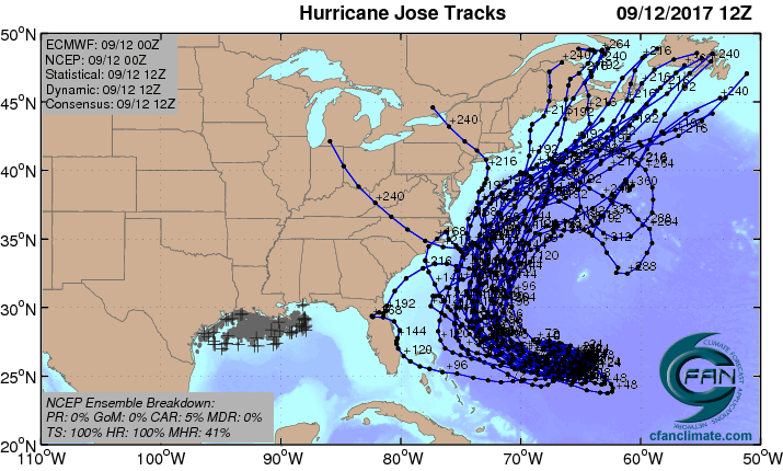
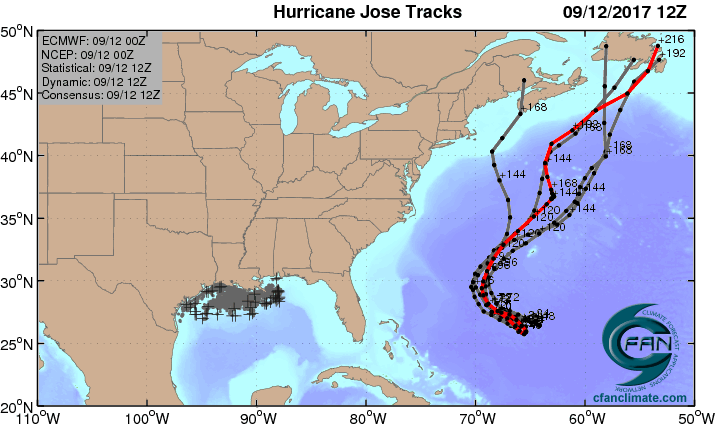
Hurricane Irma is dead, having lost its tropical characteristics and been declared post-tropical early Tuesday morning. But even as the search for survivors continues in the areas hard-hit by Irma, Hurricane Jose in the Atlantic needs to be closely watched. The latest computer models have trended towards taking Jose to the north by early next week, with no U.S. landfall likely. However, the hurricane is expected to come within a few hundred miles of the mid-Atlantic U.S. coast, and we must closely monitor this storm. Canada appears more likely than the U.S. to receive a hit from Jose at this point, but it is too early to be a believer in these long-range model forecasts. The Bahamas are now out of Jose’s 5-day cone of uncertainty, and high surf is the only impact they are likely to receive from the storm.
Intensity forecast for Jose
Jose is under high wind shear of 20 - 30 knots, and this high shear has degraded the storm significantly over the past three days, leaving it a Category 1 storm with 75 mph winds at 11 am EDT Tuesday. Satellite images on Tuesday morning showed that Jose still had plenty of intense heavy thunderstorm activity, but the storm was misshapen and asymmetrical due to the high wind shear. Continued moderate to high wind shear, combined with dry air and a passage over its own cold wake in the ocean, will likely weaken Jose to a tropical storm by Wednesday, despite very warm sea surface temperatures (SSTs) near 29.5°C (85°F) outside the cold wake. A relaxation in shear on Thursday and Friday may allow Jose to intensify some, but shear is expected to rise to the high range again over the weekend, which would halt the intensification process.
Track forecast for Jose
Jose is currently headed east at 5 mph, and is in the midst of a slow clockwise loop. (Such loops are uncommon, but not unheard of--in 2004, Hurricane Ivan did a much larger clockwise loop that resulted in two U.S. landfalls.) The rather odd forecast track is the result of a mid-level high that will move to the northeast of Jose on Wednesday, forcing it to the south and then west. The slow, looping path Jose is taking in an area of weak steering currents is the sort of behavior that our computer models don’t predict with a high degree of accuracy, and the 5-day error in the latest track forecast is likely to be higher than average. While the 12Z Monday, 0Z Tuesday, and 6Z Tuesday runs of the GFS and European models (and their ensembles) showed a limited threat to the U.S., and an increased threat to Canada next week, we should not be confident in these forecasts until Jose is done with its loop and is positioned in an area of more reliable steering currents. The UKMET model has been consistently predicting over its past three runs that Jose will move through The Bahamas and hit the U.S., but this model is an outlier, and is less likely to be correct than the consensus of our other models. Bottom line: It’s too soon to know what Jose will do, and it is certainly possible that the storm will recurve out to sea without affecting any land areas.
Seeing a favorable trend in our Calibrated ECMWF EPS that takes Hurricane #Jose out to sea. Still worth watching, but good news nevertheless pic.twitter.com/WtG9wFoyOj
— Michael Ventrice (@MJVentrice) September 12, 2017
We’ll have more on Irma in a post later today.
Bob Henson contributed to this post.
The Weather Company’s primary journalistic mission is to report on breaking weather news, the environment and the importance of science to our lives. This story does not necessarily represent the position of our parent company, IBM.