Hurricanes, Typhoons & Cyclones
Irma Brings Record Flooding to Jacksonville, Cuts Power to More Than 7 Million

Above: Pedestrians walk by a flooded car on a street as storm surge associated with Tropical Storm Irma hits Charleston, S.C., Monday, Sept. 11, 2017. Image credit: AP Photo/Mic Smith.
Hurricane Irma continued to plague residents of the Southeast U.S. even after being downgraded to a tropical storm on Monday. High-water rescues were in progress Monday afternoon in Jacksonville, Florida, where the highest storm surge on record pushed the St. Johns River to heights not seen since 1846. The shallow, concave coastline from far northeast Florida to southern South Carolina is highly vulnerable to storm surge. Persistent onshore winds—gusting to 60 mph at Jacksonville’s Naval Air Station at 10 am EDT Monday—converged on the region at midday Monday, pushing water toward the coast as a weakening Irma moved closer to the latitude of the region.
Waters along the St. Johns River in Jacksonville spiked dramatically on Monday morning, due in part to runoff from torrential overnight rains of 5” – 15” across northeast Florida (see Figure 3 below). At 1:06 pm, the gauge at downtown Jacksonville’s Main Street Bridge showed a water height of 5.57’, smashing the previous modern-day record of 4.12’ observed during Hurricane Dora on Sept. 10, 1964.

High surge extended well up the Southeast coast on Monday. The tidal gauge at Fort Pulaski, GA, near Savannah, reached its second-highest value on record (12.24’), just behind the 12.45’ set on Oct. 8, 2016, during Hurricane Matthew. Water flowed over Savannah’s seawall and into downtown streets, and parts of nearby Tybee Island reported flooding worse than during Matthew. At Charleston Harbor, the tidal gauge reading of 9.92’ came in third behind the record of 12.52’ set on Sept. 22, 1989, during Hurricane Hugo, and 10.23’ on Aug. 11, 1940. Unlike Irma, both of those earlier surges in Charleston resulted from direct hurricane hits on South Carolina. Irma gave Charleston's historic downtown its third major flood in three years, following Matthew in 2016 and the fringes of Hurricane Joaquin in 2015.
Along the southwest Florida coast, surge values came in lower than feared, thanks in part to a relatively weak southern half of Irma (the part blowing winds onshore in that region). Surge values of 2’ – 4’ were still being reported at midday Monday along Florida’s west coast.

Irma’s rains and winds continue
At 8 pm EDT Monday, Irma was located about 120 miles south of Atlanta, with top sustained winds of 45 mph. Irma will weaken to a tropical depression as it pushes into Alabama on Monday night and Tuesday, and its remnants will slow down and linger through midweek in western Tennessee and Kentucky. Heavy rainbands from Irma continued to sweep across the Southeast late Monday, and additional rainfall could total 2” – 6” across the northern side of Irma’s circulation. Tropical-storm-force winds extended into north Georgia on Monday afternoon: at 3 pm EDT, winds were sustained at 43 mph and gusting to 59 mph at Atlanta’s Hartsfield-Jackson International Airport.

Irma’s toll: A status report
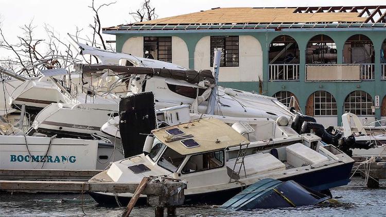
Irma is still causing havoc across the Southeast U.S., so it’s too soon for a full assessment, but here’s some of what we do and don’t know about its destructive path from the mid-Atlantic to North America.
Fatalities: Preliminary reports indicated at least 42 deaths from Irma on Monday evening, including:
Anguilla (UK): 1
Barbados: 1
Barbuda: 3
British Virgin Islands (UK): 0
Cuba: 10
Puerto Rico (US): 3
Saint Kitts and Nevis: 0
Saint Martin and Saint Barthélemy: 11
Sint Maarten: 4
United States mainland: 5
U.S. Virgin Islands: 4
Given the widespread destruction wrought by Irma, this is a remarkably low death toll. It serves as a testament to the high quality of watches and warnings for Irma, and to the value of the comprehensive evacuations carried out ahead of the storm, especially in Cuba and Florida. Evacuations are costly, time-consuming, and inconvenient, but they also save lives. One caution: Officials have yet to access and survey all of the Florida Keys, and there were fears of fatalities among Keys residents who stayed on the islands during Irma.
Costs: It’s too early for a solid estimate, but the damage appears likely to top $1 billion in each of at least six nations or territories: the British Virgin Islands, Cuba, Saint Martin and Saint Barthelemy, Sint Maarten, the U.S. Virgin Islands, and the United States mainland. A state-owned French reinsurance group, Caisse Centrale de Reassurance, reported that Irma was one of the most damaging disasters ever on French territory. “Irma is going to follow Harvey as one of the costlier hurricane events on record in the United States,” said Steve Bowen (Aon Benfield). “It is safe to assume that we are facing economic damage in the tens of billions. How many? We don't know yet. The level of cost in the past three weeks from Harvey and Irma truly is remarkable. Unfortunately, two states which are in the lead of U.S. population and exposure growth have taken direct hits by significant hurricanes.”
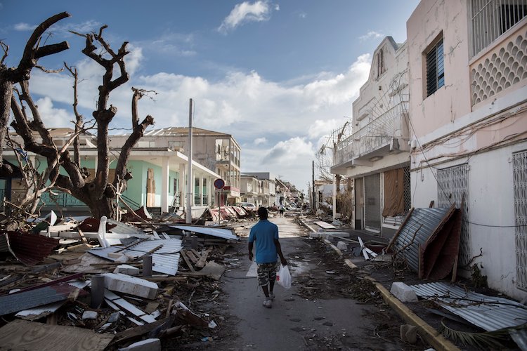
In an update published Monday, ReliefWeb reported that the islands hit by Irma suffered “severe damage to major infrastructure, health centres, loss of electricity, and limited access to clean water." Aerial imagery suggests that thousands of structures will need to be repaired or rebuilt. Over the next few days and weeks, mosquito-borne disease will become a major concern, as pools of stagnant waters left by flooding will provide ideal breeding grounds.
Power outages: As of late Monday, Irma had knocked out power to more than 7.3 million mainland U.S. customers, including roughly 3.3 million customers in Florida and at least 1.5 million in Georgia, as well as close to 1 million in Puerto Rico, where the electric grid is under particular strain. Some 30,000 utility employees will be fanning out across Florida to begin repairs. “This will be the largest-ever mobilization of [utility] line restoration workers in this country,” said U.S. homeland security advisor Tom Bossert in a press conference on Monday.
The total number of outages from Irma could exceed the 8.5 million customers in 21 states who lost power following Hurricane/Superstorm Sandy. That was the highest outage total in U.S. history, according to an analysis in Greentech Media. In a 2014 report, Climate Central found that U.S. power outages related to extreme weather events have soared in frequency in recent decades. The spike is related to an aging power grid coupled with a number of high-impact weather events. On average, major weather-related outages cost Americans between $20 and $55 billion per year. Even after reporting requirements were stiffened in 2003, the annual average number of weather-related outages doubled from 2003 to 2012. Some aspects of climate change may already be exacerbating the problem, such as intensified rain events that can make trees more vulnerable to toppling into power lines.
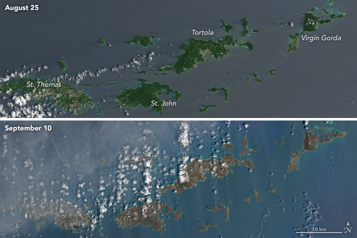
Ecology: Satellite images and aircraft fly-overs show Irma’s profound impacts on the environment. Vast amounts of sediment now extend across the Gulf of Mexico west of Florida (see embedded tweet below), and Landsat images show the “browning” of Caribbean islands (see Figure 6).
Before/after #Irma shot of S Florida. Note all the sediment stirred up in the shallow waters! MODIS imagery from https://t.co/vaXfaCS4UV pic.twitter.com/yTCw58blka
— NWS Caribou (@NWSCaribou) September 11, 2017
The Weather Company’s primary journalistic mission is to report on breaking weather news, the environment and the importance of science to our lives. This story does not necessarily represent the position of our parent company, IBM.