Frosts, Freezes, Snowflakes? Northeast Braces for a Miserably Memorable May Weekend

Above: Visible-wavelength satellite image of the storm system in the Northern Plains that will race across the Ohio Valley on Friday, May 7, 2020, and intensify at “bomb cyclone” rates by Saturday off the New England coast. (NCAR/RAL Real-Time Weather Data)
The most wintry spell of mid-May weather since last century is on tap for much of the eastern United States this weekend. Freezes will extend to the upper Ohio Valley, with frosts—possibly some of the latest ever recorded—across much of the Southern Appalachians. Damp, raw, windy conditions will sweep across big cities of the Eastern Seaboard on Friday night. And across parts of the interior Northeast, especially at higher elevations, snow is a real possibility.
The oddly wintry blast is coming from eastern Canada, pushed rapidly southeast by a compact upper low extending to heights in and near the tropopause (the dividing zone between the lowest two layers of the atmosphere). This isn’t the midwinter polar vortex you often hear about; that circulation, which is strongest in the stratosphere, has already dissipated for the season.
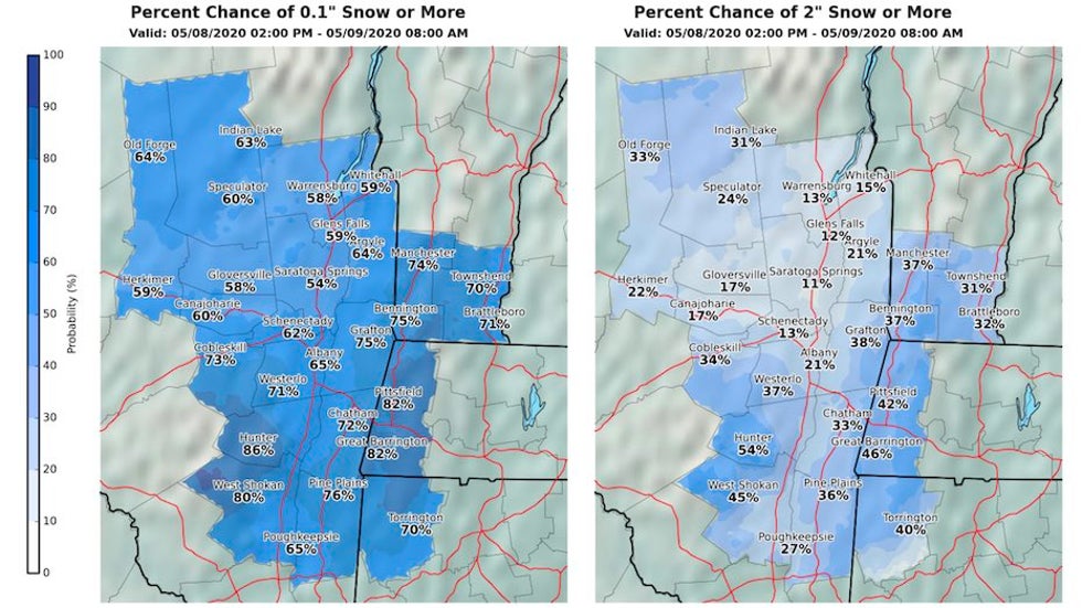
Rain and snow showers are possible Thursday night across New York and New England, where temperatures are already chillier than average. The big push of rain will hit the Ohio Valley on Friday, then sweep rapidly east of the Appalachians and up the East Coast on Friday night. Snow is expected on the west side of the precipitation shield over parts of western and central Pennsylvania, southeast New York, and southern New England. The overnight rain could mix with or briefly change to snow in the New York City area, and there is a chance of measurable snow (less than an inch in most areas) across southern New England.
Accumulating snow on grassy surfaces will be considerably more likely as you move inland and especially uphill. Recent mild weather should keep most roadways wet rather than snowy, except for some higher elevations.
Saturday will be a raw, windy day along the East Coast, with temperatures rising only into the 40s along most of the urban corridor. Extremely cold temperatures aloft for mid-spring, together with the strong May sun warming the surface, will lead to widespread instability showers. These could drop sprinkles and perhaps even a few snowflakes, most likely in the form of graupel—tiny, soft ice pellets that often have a Styrofoam-like texture and bounce when they hit pavement. A graupel shower amazed residents of West Palm Beach on January 22, when surface temperatures were well above 50°F but readings aloft were very cold.
Further inland, several inches of snow could accumulate, with localized higher amounts, across the higher elevations of Vermont and New Hampshire and much of northern Maine. Some power outages will be possible, especially with the strong winds expected.
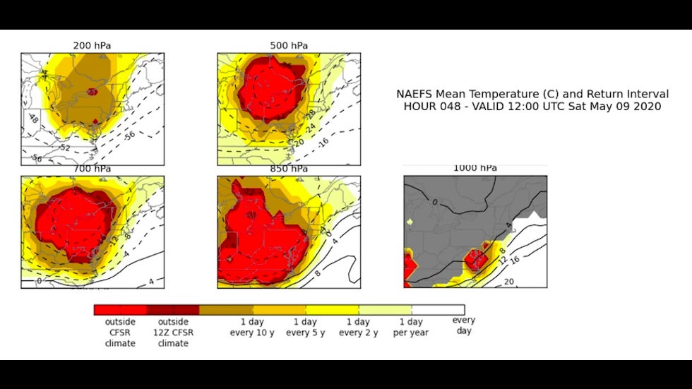
Weather Channel meteorologist Jim Cantore noted that temperatures at the 500-mb level, about 19,000 feet up, could reach –40°F (–40°C) over the Great Lakes this weekend. That would be a first anywhere in the U.S. in May, according to data from NOAA's Storm Prediction Center dating to the mid-20th century. Reflecting the extreme upper-level cold, the height of the 500-mb surface could be at its lowest over New York City for any May day on record.
As the cold upper air moves atop the relatively mild Atlantic, intensifying low pressure may become a meteorological bomb, or “bomb cyclone”—defined as a drop in the storm's central pressure of at least 24 mb in 24 hours or less—by the time it moves into the Gulf of Maine Saturday. The storm could be strong enough to set all-time May pressure records along the Maine coast, according to data compiled by David Roth (NOAAA/NWS Weather Prediction Center).
If that wasn't enough, Roth noted the strength of high pressure could set May records over the Canadian Arctic.
Yet another rare consequence of the extremely cold upper-level air: some lake-effect snowbands may develop downwind from the Great Lakes on Saturday. The instability needed to produce lake effect is most common in the autumn and early winter, when frigid air passes over the still-mild lakes; it becomes far more unlikely by mid-spring, when the air tends to be milder and the lake waters are still chilly from winter.
Across parts of interior New York, snow squalls could be intense, with thunder and lightning and sharp changes in visibility.
Dozens of daily record lows and record-cold highs can be expected throughout the eastern U.S. this weekend. Temperatures could approach some all-time May record lows in a few spots this weekend, including Detroit (25°F), Lexington, Kentucky (26°F), Pittsburgh (26°F), Indianapolis (28°F), Knoxville, Tennessee (32°F) and Nashville (34°F).
When did this last happen?
This weekend’s Northeast snow appears to be the type that one would expect in mid-May only every few decades, and perhaps even less often in our inexorably warming climate. According to Tomer Burg (@burgwx), some analog events include May 10, 1945; May 9-10, 1977; and May 17-18, 2002.
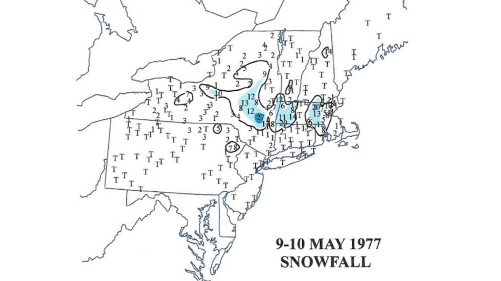
The May 1977 event was a true shocker. More than 11.4” of snow fell in Worcester, Massachusetts, and up to 20 inches was reported in parts of Connecticut. Providence measure 6.7”, Boston’s Logan Airport picked up 0.5”, and even New York’s Central Park reported its latest trace snow on record. “In all the years of record keeping—which, in some cases, go back the 1870s—there are no other May storms which come remotely close to what occurred back in 1977,” noted Boston.com’s Dave Epstein. Power was knocked out to more than half a million customers.
Going back even further, there were reports of “a considerable quantity of snow” in both Philadelphia and New York on May 4, 1774. For more on some of the greatest late-season U.S. snows on record, see the recent post by Chris Burt.
See weather.com for the latest forecasts of this unusual event.
The Weather Company’s primary journalistic mission is to report on breaking weather news, the environment and the importance of science to our lives. This story does not necessarily represent the position of our parent company, IBM.