Hurricanes, Typhoons & Cyclones
Extremely Dangerous Cat 5 Irma Storms into Leeward Islands

Above. MODIS image of Hurricane Irma taken on Tuesday afternoon, September 5, 2017. At the time, Irma was a Category 5 storm with 185 mph winds. Image credit: NASA.
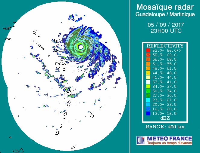
Thousands of people across the far-flung northern Leeward Islands battened down for the worst on Tuesday evening as Hurricane Irma approached. Irma surged in strength on Tuesday to become the strongest Atlantic hurricane ever recorded north of the Caribbean and east of the Gulf of Mexico. As of 2 pm EDT Tuesday, Irma’s top sustained winds were an incredible 185 mph. The only hurricane anywhere in the Atlantic ever known to have stronger winds was Allen (1980), at 190 mph. Allen weakened to Category 3 before striking the Texas/Mexico border.
At 8 pm EDT, Irma was centered about 85 miles east of Antigua, moving just north of due west at about 15 mph. On its current track, Irma’s center will pass near or just between Antigua and Barbuda during the predawn hours Wednesday, and one or both islands could wind up in the extreme winds of Irma’s eyewall. Later Wednesday morning, Irma will be approaching St. Kitts and Nevis, Anguilla, and St. Barthelemy, and by Wednesday afternoon Irma’s core will likely be nearing the British Virgin Islands. Irma is in the midst of a very subtle turn toward the west-northwest, which may take its center just north of the U.S. Virgin Islands and Puerto Rico. However, all of these islands lie close enough to Irma’s path to require full-scale preparations for a potentially devastating hit. A hurricane with top winds of 185 mph has never been recorded in these islands. The most recent close analog may be Hurricane Hugo (1989), which tore through the Leewards and struck Puerto Rico as a Category 4 storm, causing $3 billion in damage (1989 dollars) and 72 deaths. Irma’s track is expected to be similar but slightly north of Hugo’s.

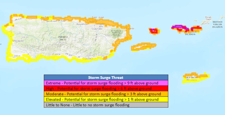
Hurricane Warnings are in effect throughout the Northern Leeward Islands, Puerto Rico, and the U.S. and British Virgin Islands, as well as the north coast of the Dominican Republic. The NHC forecast brings Irma’s center very close to the north coast of Hispaniola, which could be affected by the storm’s southern eyewall by Thursday. The topography of both Puerto Rico and Hispianola is likely to help generate torrential rains, including on the south sides of these islands; flood-prone areas of Haiti may be at particular risk, given that nation’s vulnerability to floods and mudslides. Northwest Haiti, southern Cuba, and the southern Bahamas could see 8" - 12" of rain. Significant storm surge is possible along the north coasts of islands that lie south of Irma’s path, and extreme storm surge is possible across the Turks and Caicos and the Southeast Bahamas as Irma draws closer. Potential surge amounts noted by NHC in its 5 pm EDT advisory include:
Northern Leeward Islands...7 to 11 ft
Turks and Caicos Islands...15 to 20 ft
Southeastern Bahamas...15 to 20 ft
Northern coast of the Dominican Republic...3 to 5 ft
Northern coast of Haiti and the Gulf of Gonave...1 to 3 ft
Irma sets a record as strongest hurricane in open Atlantic
As noted above, Irma’s peak sustained surface winds of 185 mph are the highest observed in any hurricane north of the Caribbean and east of Florida, topped only by Allen (1980) in the Caribbean (190 mph). Two hurricanes have notched 185-mph winds in the Caribbean: Gilbert (1988) and Wilma (2005). The Labor Day hurricane of 1935 hit the same peak winds in the Florida Straits.
Irma set another record late Wednesday afternoon: its central surface pressure dropped to 916 mb, as extrapolated from dropsonde data collected by Hurricane Hunters. Update: This is just short of the previous Atlantic record outside of the Caribbean and Gulf of Mexico, a 915 mb reading from a dropsonde with Hurricane Isabel (2003).
Irma's central pressure at 2 pm EDT Tuesday, when the hurricane's top winds first hit 185 mph, was 926 mb. Interestingly, the other four Atlantic hurricanes with winds at least that strong had significantly lower central pressures:
Wilma: 882 mb
Gilbert: 888 mb
Labor Day 1935: 892 mb
Allen: 899 mb
Why the difference? Wind speeds are driven by the contrast between the central pressure of a hurricane and its surrounding environment. As a rule, the sharper the contrast, and the smaller the distance over which it occurs, the stronger the peak winds. Normally, one would expect a medium-sized hurricane like Irma with a central pressure of 926 mb to have slightly weaker winds. However, surface pressures around Irma are considerably higher than usual, which appears to have boosted the pressure gradient, according to Philippe Papin (University at Albany, SUNY).
As a hurricane matures, its wind field often spreads out while the peak winds slowly decrease. The hurricane’s storm surge potential does not necessarily drop, though, because the broadened wind field can be pushing just as much water as before. Hurricanes such as Ike (2008) and Sandy (2012), whose winds weakened before landfall, produced much more surge than one might have expected from their Saffir-Simpson rating, which depends only on maximum wind speed. A storm as powerful as Irma will have the potential to create devastating storm surge even if its wind field eventually expands and its top winds weaken.

Track forecast for Irma near Florida
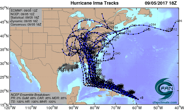
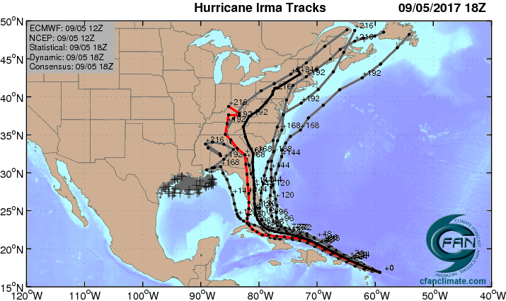
Irma poses the most serious hurricane threat to northern Cuba and Florida since at least Hurricane Andrew (1992). As a whole, the 12Z Tuesday model cycle showed little difference from the 0Z model cycle, with Irma expected to move west-northwest through The Bahamas and potentially hit northern Cuba before making a sharp right-hand turn between Cuba and South Florida. The level of agreement among models and over time has been quite high for a forecast in the 5-day range. Given this agreement and Irma’s Category 5 strength, residents of Florida must take this hurricane with the utmost seriousness.
What is not yet certain is whether Irma will travel along Florida’s west coast or its east coast, offshore from one or the other, or along the spine of the Florida peninsula. Any of these paths could bring significant and potentially devastating impacts to large parts of the state. There remains a chance, as seen in two of the high-probability members of the 12Z European ensemble model forecast (Figure 7), that Irma will make a sharp enough turn to miss Florida completely and head north through The Bahamas. This was also the solution of the latest 18Z Tuesday run of the GFS model. However, the stakes are too high for Floridians to count on that possibility.
The 5 pm EDT Tuesday Wind Probability Forecast from NHC highlighted a number of Florida locations with chances of seeing hurricane-force winds by Sunday evening, with the highest odds in the Florida Keys and South Florida:
24%: Key West
23%: Marathon
14%: Miami
11%: Naples
8%: West Palm Beach
8%: Ft. Myers
3%: Tampa
The take-home message: while it is too soon to rule out other possibilities, Irma has a good chance of moving northward close enough to the Florida peninsula for significant impacts to large parts of the state, potentially devastating in some areas. Irma may be moving at 10 mph for a day or more after it makes its northward turn, which will prolong the period of high winds and heavy rains within its circulation. Even if it moves along Florida’s west coast, residents on the East Coast could still receive hurricane-force winds, significant storm surge, and torrential rains of 10 - 15” or more. Depending on Irma’s track, some areas could experience 8 hours or more of hurricane-force wind and 24 hours or more of tropical-storm-force wind. The National Hurricane Center reminds us not to focus on the exact forecast track, though, especially at the longer ranges, since the average NHC track errors are about 175 and 225 miles at days 4 and 5, respectively.

Tropical Storm Jose gaining strength in Central Atlantic
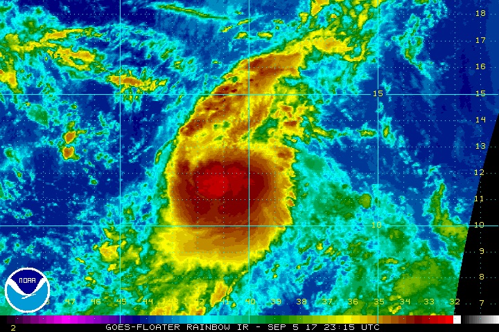
Tropical Storm Jose, christened on Tuesday morning, was moving west-northwest at 10 - 15 mph with top sustained winds up to 45 mph as of 5 pm EDT. Satellite images on Tuesday showed plenty of spin, and heavy thunderstorm activity was gradually increasing and growing more organized. Conditions were favorable for development, with moderate wind shear of 10 - 15 knots, SSTs near 28.5°C (83°F), and a moist surrounding atmosphere.
The 12Z Tuesday operational runs of our three reliable models for predicting tropical cyclone genesis—the GFS, European and UKMET models—all predicted further development of Jose, on a northwestward-curving track that will most likely keep it northeast of the Leeward Islands. Only a few of the 50 members of the 12Z Tuesday European model ensemble forecasts showed Jose affecting the Leewards late this week. The official NHC forecast as of 5 pm Tuesday takes Jose within about 100-200 miles of the Leeward Islands as a strong Category 2 hurricane by Saturday, so high surf, gale-force winds, and some rain may be possible. The GFS and Euro predict that Jose will stall well southwest of Bermuda, possibly carrying out an unusual cyclonic loop later next week, but track forecasts at this long range have very little accuracy.
Because Jose and Irma are more than 1000 miles apart, their tracks are unlikely to be influenced by the Fujiwhara effect. However, outflow from Irma could produce vertical shear that may slow Jose's development later this week.
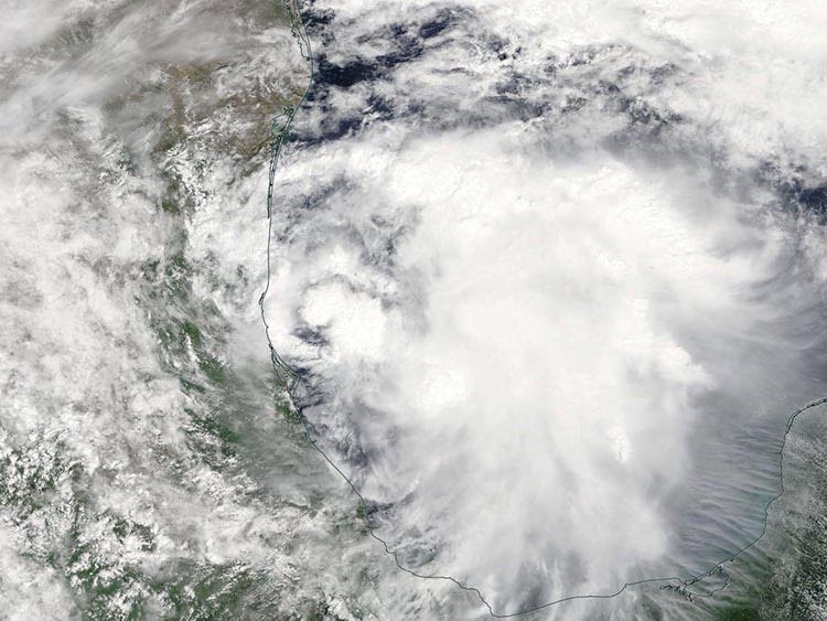
Tropical Depression 13 develops in Gulf of Mexico
A trough of low pressure in the southwestern Gulf of Mexico’s Bay of Campeche became Tropical Depression 13 on Tuesday afternoon. The system was producing increasingly organized heavy thunderstorms on Tuesday, as seen on satellite imagery. SSTs are very warm, near 30.5°C (87°F), but wind shear is high, 20 – 30 knots. As of 5:00 pm EDT Tuesday, TD 13 was located about 80 miles east of Tampico, Mexico, drifting east at just 2 mph with top sustained winds of 35 mph.
Our three most reliable models for longer-term hurricane prediction—the European, GFS, and UKMET—predicted in their Tuesday morning runs that TD 13 would affect the coast of Mexico between Veracruz and Tampico with heavy rains late this week. Strong upper level winds out of the northwest over the Gulf of Mexico should keep TD 13 bottled up in the southwestern Gulf of Mexico near the coast of Mexico this week. All of the 20 members of the GFS ensemble runs from 12Z Tuesday, and about 2/3 of the 50 members of the European ensemble runs from 12Z Tuesday, intensified TD 13 into a tropical storm. None of the 70 ensemble members strengthen TD 13 into a hurricane, though.
Dr. Jeff Masters co-wrote this post.
Awe-inspiring. Category 5 #HurricaneIrma GOES-16 30-second imagery, 500-meter resolution "Red" Channel. (Prelim/Non-operational) pic.twitter.com/J1SfqDXNFJ
— Mike Umscheid (@mikeumsc) September 5, 2017
Hang on, Bird International (Antigua) ... right now NNW at 20kts .. #Irma #flwx #scwx #gawx #ncwx pic.twitter.com/FzBjUFFFuv
— Greg Postel (@GregPostel) September 6, 2017
The Weather Company’s primary journalistic mission is to report on breaking weather news, the environment and the importance of science to our lives. This story does not necessarily represent the position of our parent company, IBM.