Hurricanes, Typhoons & Cyclones
Disturbance That May Develop This Weekend Bringing Heavy Rains to Cuba, Florida

Above: GOES-East satellite image of an area of disturbed weather over the northwest Caribbean, Cuba, and Florida, taken at 11:45 am EDT May 21, 2018. Areas of lightning activity are overlaid in color. Image credit: NOAA/RAMMB.
For the second time this month, we have an area of disturbed weather in the Atlantic that threatens to bring an early start to the Atlantic hurricane season--which officially begins on June 1. Last week, an area of disturbed weather, to which the National Hurricane Center (NHC) gave 5-day development odds as high as 40%, came ashore along the Gulf Coast of Florida without developing into a tropical or subtropical depression. That system brought heavy rains of 3 - 5” over much of Florida on May 14 – 16.
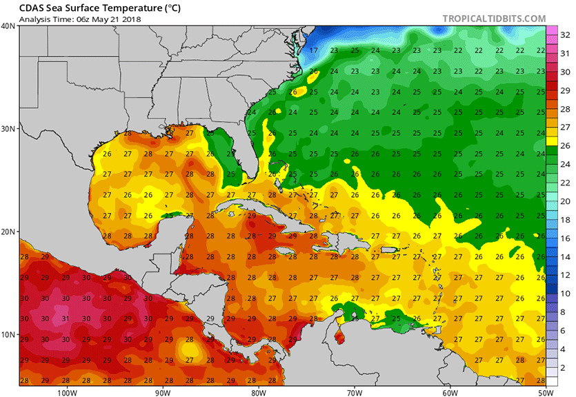
This week, another area of disturbed weather, associated with an upper-level low pressure system interacting with a weak area of surface low pressure, is over the northwest Caribbean, Cuba, and Florida. This system is unusually moist (with precipitable water levels near 2”), and is bringing disorganized thunderstorms with very heavy rain to the region. This activity will move slowly northward through the central and eastern Gulf of Mexico over the next few days, where sea surface temperatures (SSTs) range from 25 - 28°C (77 - 82°F)—near the lower limit of 26.5°C (80°F) that is typically needed for a tropical depression to form. The system will be moving over these marginally warm waters for several days, and has the potential to gradually acquire tropical characteristics and become a warm-cored tropical depression by the weekend. Wind shear over the system was a high 20 – 40 knots on Monday, and was predicted to stay high through at least Wednesday, making development unlikely until Thursday at the earliest.
A wide range of model predictions
The 0Z Monday operational runs of our top three models for predicting tropical cyclone genesis--the European, GFS and UKMET models—had one of these models, the European, predict that a tropical depression would form by Saturday, in the waters a few hundred miles south of Louisiana. The European model predicted a fall in wind shear to a moderate 10 – 20 knots on Thursday through Saturday over the Gulf of Mexico, favoring tropical cyclone formation. The 0Z Monday operational run of the GFS model kept wind shear high all week, discouraging development; the 06Z and 12Z runs of the GFS model were similar to the 0Z run. However, about 40% of the model’s ensemble members predicted a tropical depression would form over the eastern Gulf of Mexico late this week. These solutions predicted a track for the storm into the Florida Panhandle by early next week. None of the ensemble members of the 0Z Monday European or GFS models predicted that a hurricane-strength storm would occur. The 0Z Monday run of the UKMET model predicted that development of a tropical depression would occur in the western Caribbean on Sunday, while the 12Z run predicted development in the south-central Gulf of Mexico on Sunday.
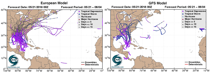
That’s a pretty wide range of solutions from our top models; formation of a tropical depression from this messy system is not a slam-dunk, and will be slow to occur. In a special 8:30 am EDT Monday Tropical Weather Outlook, The National Hurricane Center gave the system 2-day and 5-day odds of development of 0% and 20%, respectively. As of Monday morning, NHC had not yet designated this system as an “Invest”—an area of interest worthy of running their special tropical cyclone prediction models for. The first name on the Atlantic list of storms for 2018 is Alberto.

Heavy rains the main threat
Regardless of development, the counter-clockwise flow of air around this low-pressure system in combination with a very wet tropical airmass will funnel large amounts of tropical moisture over Cuba and the Southeast U.S., resulting in very heavy rains during the coming week. Asheville, North Carolina has already recorded their wettest May on record (9.67 inches) with still 11 days to go. They are only 4.08 inches from matching the wettest month of all-time: 13.75” in August 1940.
Bob Henson contributed to this post.
The Weather Company’s primary journalistic mission is to report on breaking weather news, the environment and the importance of science to our lives. This story does not necessarily represent the position of our parent company, IBM.