Deja Vu for the South: Another Severe Outbreak at Hand

Above: A woman looks at a home on Monday, April 13, 2020, near Nixville, South Carolina, after it was leveled by a tornado earlier in the day. (Sean Rayford/Getty Images)
Exactly one week after a swarm of more than 100 tornadoes ripped from Texas to Maryland, parts of the region are facing another bout of significant severe weather on Sunday. Update: At midday Sunday, April 18, the NOAA/NWS Storm Prediction Center had placed a swath from northern Louisiana to southern Georgia under a moderate risk of severe weather (level 4 on SPC’s 1-to-5 scale). A surrounding enhanced-risk area (level 3) extended from southeast Texas to southeast South Carolina.
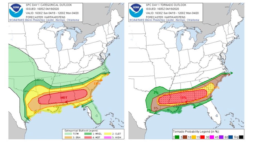
The region under the gun for Sunday has an uncanny amount of overlap with the hardest-hit areas from the outbreak on April 12-13, which killed more than 30 people and destroyed or damaged hundreds of homes.
The saving grace is that the upper-level storm system and the associated surface low won’t be quite as strong as they were last time, so there’s a good chance that fewer of the day’s storms will be tornadic. Still, SPC warned that strong tornadoes are a possibility—and unfortunately, these are most likely to occur in the moderate risk area, which also saw some of the worst storms on Easter Sunday.
There’ll be no lack of access to muggy, unstable air, with low-level winds flowing off the exceptionally and unseasonably warm Gulf of Mexico. As was the case last Sunday, thunderstorms are likely to congeal along a warm front moving slowly northward across Louisiana, Mississippi, Alabama, and Georgia. These storms will dump torrential rain, locally up to 7"—there’s a moderate risk of flash-flood-producing downpours in this area—and they could also spin up embedded tornadoes. Heavy rains on Saturday night heightened the flood risk for parts of this area. This year so far is the wettest on record in Birmingham, Alabama, which picked up another 1.67" overnight on top of 33.56" for 2020 so far.
Just south of the warm front is where tornadic supercell storms would be most likely to occur, again much like the last go-round.
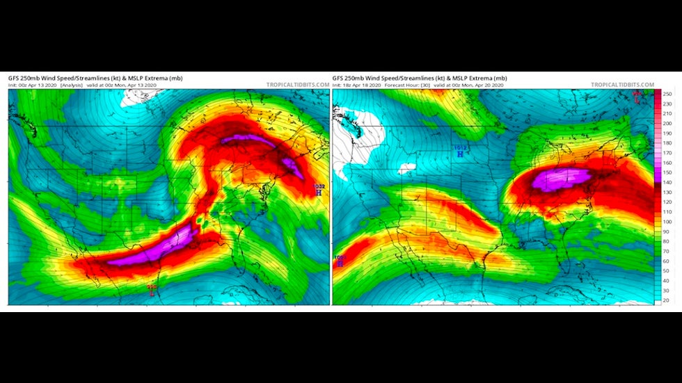
The big difference between the two Sunday setups is that upper-level forcing will be considerably weaker on April 19 vs. April 12. On Easter Sunday, a disturbance in the polar jet stream was kicking out a cold upper low across Texas, which led to exceptionally strong vertical wind shear and upper-level divergence (a “parting of the waters” wind pattern that favors rising air). A pocket of winds at the 250-millibar level (about 34,000 feet) exceeded 160 mph on Sunday night, April 12, over Louisiana, as shown below.
The forecast for Sunday night, April 19, again shows divergence over the moderate-risk area, but the strongest incoming winds at the 250-mb level will be closer to 120-130 mph.
Winds at other levels will also be considerably weaker, especially near the surface and at some distance from the surface low that’s forecast to move from Louisiana into Mississippi on Sunday night. As a result, the type of low-level wind shear that leads to the strongest tornadoes will likely affect a smaller area as compared to April 12.
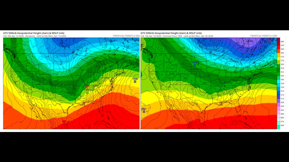
With all that said, we’re in the last half of April—close to peak season for tornadoes—and there will easily be enough upper-level energy and unstable air to spin up one or more dangerous tornadic supercells. Whether it’s a widespread outbreak or a single storm makes no difference if you happen to be in the path of a tornado.
Embedded tornadoes will also be possible well into Sunday night as storms congeal into lines or clusters. Much like last week, severe weather could extend into Monday morning as the storms move off the coast of the Carolinas and Georgia, though the chance of numerous intense morning tornadoes appears a bit lower this time.
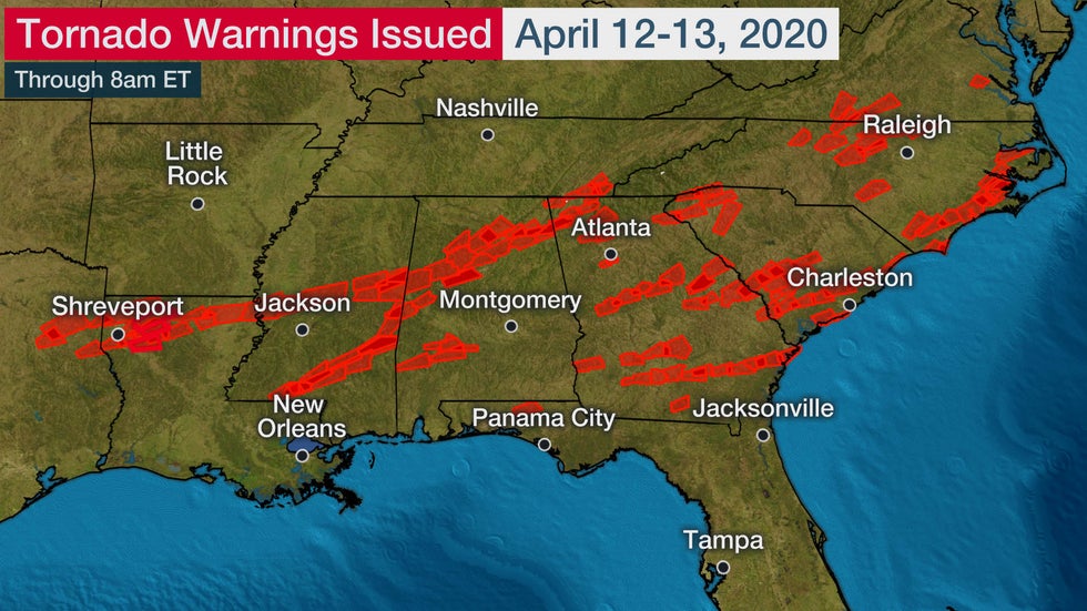
The number of tornadoes spun out from midday Sunday to midday Monday—at least 130—was the highest in a two-day period since the catastrophic Super Outbreak of April 26-27, 2011. The number of EF3 tornadoes was also the highest two-day total since that devastating outbreak.
A total of ten states saw tornadoes on Sunday and Monday, stretching from Texas to Maryland.
View @SteveBowenWx's post on X
Where do the most widespread tornado outbreaks tend to occur?
Though it’s easy to think of the Great Plains’ Tornado Alley as the most likely place to get a strong twister—and by many measures, it is—the outbreaks that affect the largest number of states tend to occur farther east.
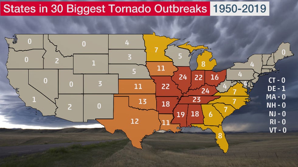
This graphic shows how many of the 30 days with the most widespread tornado outbreaks from 1950 to 2019 affected each of the contiguous U.S. states. The top-30 list is based on how many states saw at least one tornado originate in that state on a given day, with each day starting and ending at 7 a.m. EST (8 a.m. EDT).
For more on this new analysis, see my article published Saturday at weather.com.
The Weather Company’s primary journalistic mission is to report on breaking weather news, the environment and the importance of science to our lives. This story does not necessarily represent the position of our parent company, IBM.