Hurricanes, Typhoons & Cyclones
Cristobal Pushes Onto Louisiana Coast

Wunderground composite radar image of showers and thunderstorms around Tropical Storm Cristobal as of 1854Z (2:54 pm CDT) Sunday, June 7, 2020. (NWS, via WU)
Tropical Storm Cristobal was lumbering ashore Sunday afternoon across southeast Louisiana, making for the second U.S. named-storm landfall this year after marginal Tropical Storm Bertha. As of 2 pm EDT, the NOAA/NWS National Hurricane Center placed the center of Cristobal about 30 miles south-southeast of Grande Isle, Louisiana, moving north at 5 mph. Top sustained winds were holding steady at around 50 mph. Update (6:45 pm EDT Sunday): According to NHC, Cristobal made landfall at 6 pm EDT along the coast of southeast Louisiana between the mouth of the Mississippi River and Grand Isle.
View @NWSNewOrleans's post on X
Cristobal’s structure on Sunday afternoon was far from that of a classic symmetric tropical cyclone. As well predicted by models, Cristobal has been right-weighted, with the weather far more active on its right-hand (east) side than on its left-hand (west) side.
What’s interesting from a modeling perspective is that several models, including the GFS and HWRF, successfully captured the idea that Cristobal would have a vortex-within-a-vortex structure. The most distinct area of low-level spin approached the Louisiana coast on Sunday while rotating around the north side of a broader area of circulation. Meanwhile, another area of low-level spin was evident moving eastward around the south side of Cristobal’s larger circulation, a bit further offshore (see visible satellite image below). In its 2 PM advisory, NHC appeared to place the center of Cristobal in between these small-scale vortexes, near the center of the broader circulation.
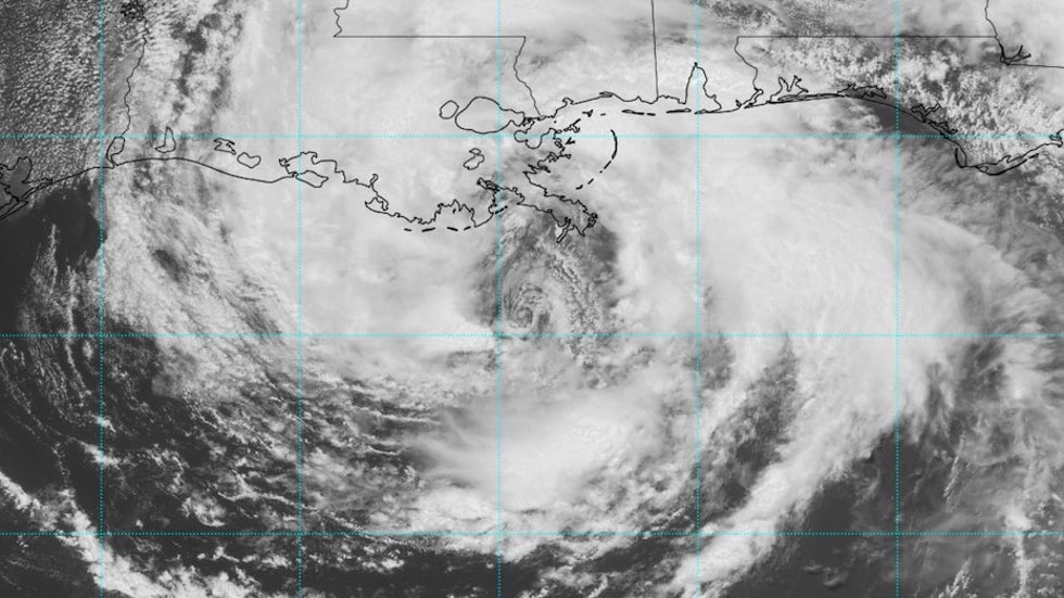
Cristobal’s large size and unorthodox structure, along with a profusion of dry air in the western Gulf of Mexico, kept the storm from strengthening significantly atop warm sea-surface temperatures across the Gulf of Mexico. That large size also fostered a powerful band of showers and thunderstorms (convection) that pushed across western and northern Florida.
One thunderstorm spawned a confirmed tornado in the Orlando area on Saturday evening. More tornadoes are possible Sunday afternoon and evening northeast of Cristobal’s center, especially over far southern Mississippi and Alabama, where a tornado watch was in effect until 5 pm CDT.
Rainfall totals of 4” – 6” for the 24-hour period ending Sunday morning were widespread across Pinellas County in the Tampa Bay area, and a 24-hour total of 7.02” was reported late Sunday morning at a CoCoRaHS site about seven miles west of Jacksonville.
Tropical-storm-force sustained winds were limited to areas off the coast of southeast Louisiana as of early afternoon Sunday. Winds were sustained at 51 mph and gusting to 57 mph at a height of 53 meters (173 feet) at an offshore platform about 100 miles south of Mobile, Alabama.
Floodwaters push into the Mississippi Delta
As expected, storm surge on Cristobal’s right-hand side was extensive but not severe in most areas. One exception was in vulnerable far southeast Louisiana and southern Mississippi, just northeast of Cristobal’s center. Storm surge at Shell Beach, Louisiana, reached 5.3’ and water levels reached 7.0’ above mean lower low water (MLLW) around 2:30 pm EDT Sunday. Storm surge reached 4.3’ at Bay Waveland Yacht Club, Mississippi.
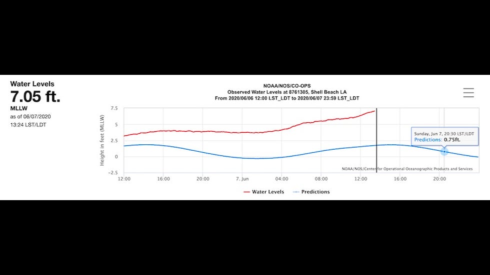
Other peak storm surge values (independent of tides) around 2 pm EDT Sunday included:
Grand Isle, LA: 2.1’
Dauphin Island, AL: 2.3’
Pensacola, FL: 2.0’
Apalachicola, FL: 1.9’
Cedar Key, FL: 2.4’
See the frequently updated weather.com article for more on Cristobal’s impacts.
View @brianemfinger's post on X
A wet footprint
Cristobal will dump widespread 5” – 10” rains on its east side across the Mississippi Delta of southeast Louisiana and southern Mississippi as it slogs inland and heads northwest across Louisiana. At midday Sunday, the NOAA/NWS Weather Prediction Center issued a high risk of excessive rain leading to flash floods across this area from Sunday afternoon into early Monday. Training echoes will be a particular concern on Sunday night on the southeast flank of Cristobal.
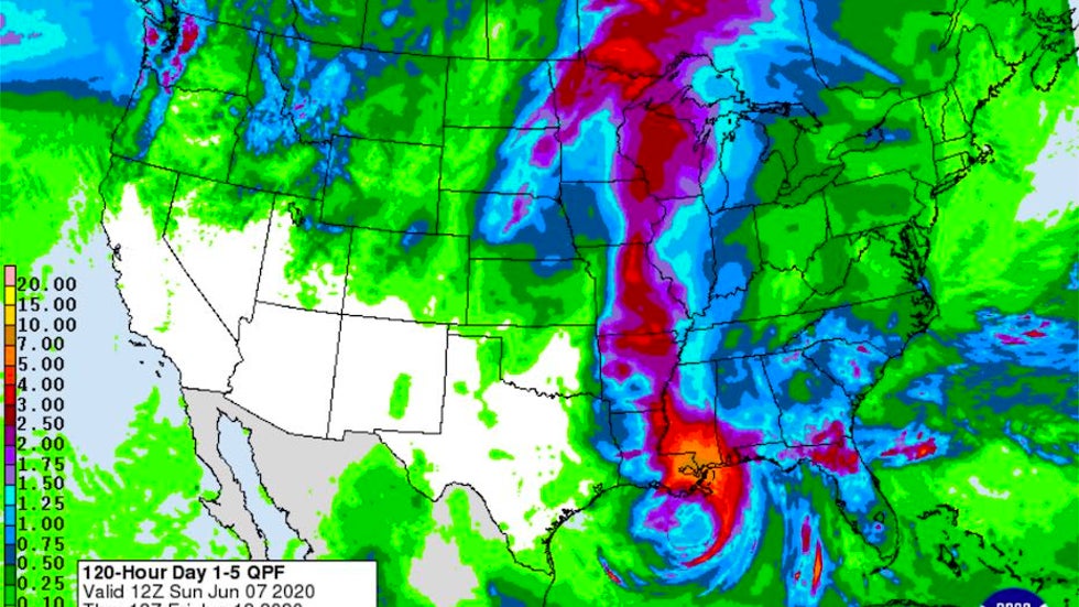
By Monday, as it takes on post-tropical characteristics, Cristobal will be accelerating northward into a strong midlatitude storm system cruising across the Northern Plains toward the Midwest. A corridor of 2” – 5” rains can be expected from Arkansas and Missouri into Iowa and Wisconsin, and some of Cristobal’s moisture will help fuel additional heavy rain into northern Minnesota.
WPC has a moderate risk of excessive rain/flash flooding on Monday from southern Mississippi to eastern Arkansas, with the possibility of training/persistent rainbands across at least some of this area.
The Weather Company’s primary journalistic mission is to report on breaking weather news, the environment and the importance of science to our lives. This story does not necessarily represent the position of our parent company, IBM.