Hurricanes, Typhoons & Cyclones
Arthur Strengthens En Route to North Carolina

Above: High-resolution visible satellite image of Tropical Storm Arthur from 1622Z (12:22 pm EDT) Sunday, May 17, 2020. (tropicaltidbits.com)
A tropical storm warning was in effect along the North Carolina coast as the first named storm of the Atlantic season, Arthur, slowly intensifies. As of 11 am EDT Sunday, a tropical storm warning is in effect from Surf City north to Duck, including the Pamlico and Albemarle sounds. Arthur was centered at 11 am EDT about 345 miles south-southwest of Cape Hatteras, NC, and moving north-northeast at about 9 mph. Top sustained winds in Arthur were 45 mph, according to the NOAA/NWS National Hurricane Center (NHC).
Arthur was a highly asymmetric storm on Saturday night—more like a subtropical storm in some ways, with most of its strong showers and thunderstorms (convection) east of its center. On Sunday, Arthur appeared to be organizing more solidly in tropical-storm mode. Convection remained fragmented and still mostly on the north and east sides of Arthur, but the storm’s circulation was becoming more symmetric. With wind shear reduced from Saturday, the upper-level outflow had improved.
Outlook for Arthur
Upper-level wind shear will remain light (less than 10 knots) over Arthur through Sunday, giving the storm a window to organize and intensify. Sea surface temperatures of around 25-26°C (77–79°F) are below the usual threshold of 26°C for tropical development, but Arthur’s northward trek over the Gulf Stream will give it access to the warmest possible water, and cold air aloft will help compensate for the reduced instability from the less-than-toasty water. The mid-level air in the vicinity of Arthur will remain moderately moist (relative humidity of 55–65%), although dry air intrusions from land may hinder Arthur's convection at times.
Southwesterly flow ahead of a deep trough in the central U.S. will continue to steer Arthur north-northeastward over the next day or so. This track will bring Arthur over or near the Outer Banks of North Carolina on Monday, with a brief landfall possible. By this point, NHC predicts that Arthur will be a 60-mph tropical storm. Impacts in the Outer Banks be limited by the angle of approach, which will minimize storm surge and keep Arthur’s strongest winds mainly offshore. Squally tropical-storm-force winds and doses of heavy rain will be possible across and near the Outer Banks, mainly in the 1-2” range but up to 4” locally.
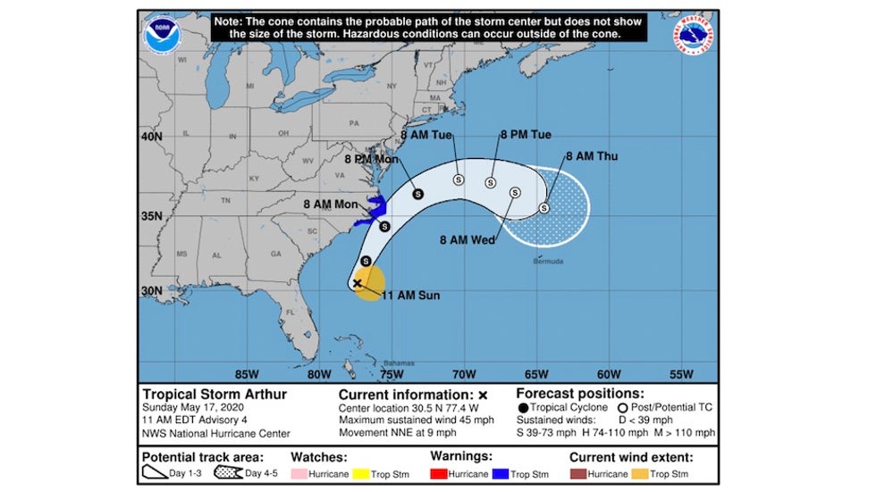
Beyond North Carolina, Arthur will likely turn eastward out to sea, as reflected in the official NHC forecast on Sunday, becoming a post-tropical storm as it encounters much higher wind shear and cooler water. However, this standard curving-out-to-sea scenario is complicated somewhat by the approaching upper trough, which is expected to settle into the Southeast as a large cut-off upper low from Tuesday till at least Thursday.
The 0Z Sunday ensemble runs of the European (ECMWF) model are in strong agreement on the turn offshore. A handful of runs from the GFS ensemble run, and the 12Z Sunday operational run of the GFS model, show Arthur stalling east of the Delmarva peninsula and perhaps making a half-hearted run back toward the mid-Atlantic coast later next week. The 12Z Sunday HWRF model, though not a top-performing track model, depicts a similar outcome. This is an unlikely scenario, but it can’t yet be ruled out. Even if it were to occur, Arthur would almost certainly be only a minimal tropical storm or tropical depression, after having spent several days over the chilly waters north of the Carolinas.
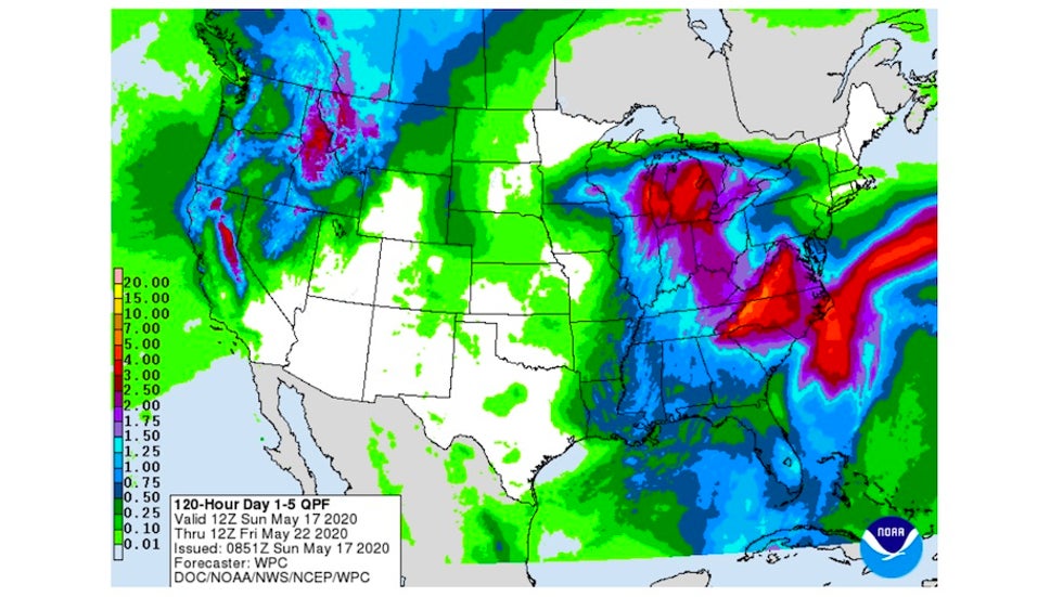
Whether or not Arthur gets drawn into the picture, the upper low boosts the odds that cool, showery conditions will prevail next week across a large area. Widespread 1-4” rains are possible from South Carolina to Maryland, and local totals could be considerably higher, especially toward the eastern slopes of the Appalachians.
Especially if Arthur slows or stalls well offshore, its presence will boost a long onshore fetch and exacerbate winds, waves, and beach erosion along the coast from Delaware to Massachusetts during much of the coming week.
View @webberweather's post on X
Yet another early-season named storm
The Atlantic’s hurricane season doesn’t officially start till June 1, but it’s become increasingly common in recent years to get our first named storm in the pre-season period, as is the case with Arthur. Each year since 2015 has had at least one named storm before June 1, and there were a total of eight pre-June named storms in the last decade, as shown below. All of these were tropical storms unless otherwise noted.
2012: Alberto (May) and Beryl (May)
2015: Ana (May); became a subtropical storm, then tropical storm
2016: Alex (January), a hurricane affecting the Azores, and Bonnie (May)
2017: Arlene (April); began as a subtropical depression, then tropical depression and tropical storm
2018: Alberto (May); became a subtropical storm, then tropical storm
2019: Andrea (May), subtropical storm
While all this suggests a trend may be afoot, and that perhaps the start date of hurricane season ought to be moved up, the reality is more complicated. For an excellent roundup of thinking along these lines, see the essay published Friday in Forbes by Weather Geeks podcast host Marshall Shepherd: “Why The June 1st Start Date Of Hurricane Season Is Just Fine.”
Fast-strengthening Amphan a serious threat to far eastern India and Bangladesh
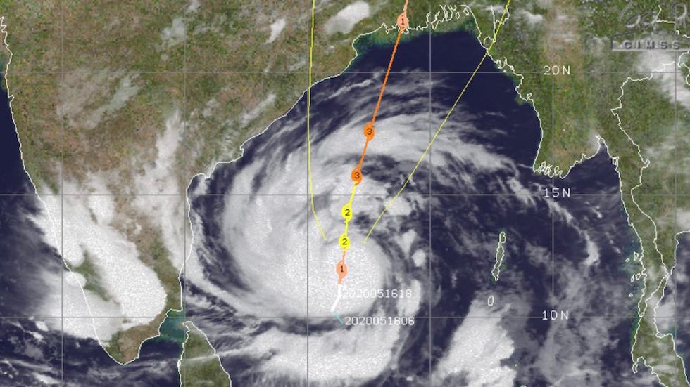
Large, rapidly intensifying Cyclone Amphan—a Category 4 equivalent as of Sunday afternoon, with top sustained winds of 130 mph—is heading toward an expected landfall on the coast of far eastern India or Bangladesh on Wednesday or early Thursday local time. Amphan's breakneck strengthening on Sunday from Cat 1 to Cat 4 strength was consistent with forecasts from the high-resolution HWRF model, which has been calling for Amphan to become an extremely dangerous cyclone. While Amphan may weaken slightly before landfall, it will still generate a potentially catastrophic storm surge, accentuated by the geography of the Bay of Bengal.
The GFS and ECMWF models have come into close agreement on a track that would bring Amphan onshore near the city of Kolkata, India, as reflected in the Joint Typhoon Warning Center forecast issued on Sunday afternoon. This would put low-lying areas of far eastern India and western Bangladesh at risk of severe storm surge.
For more details on the extreme vulnerability of this area, see our Category 6 post from Saturday.
The Weather Company’s primary journalistic mission is to report on breaking weather news, the environment and the importance of science to our lives. This story does not necessarily represent the position of our parent company, IBM.