Powerhouse Storm to Bring Tornadoes, Hail, Wind, Flooding Rain, Snow, Ice

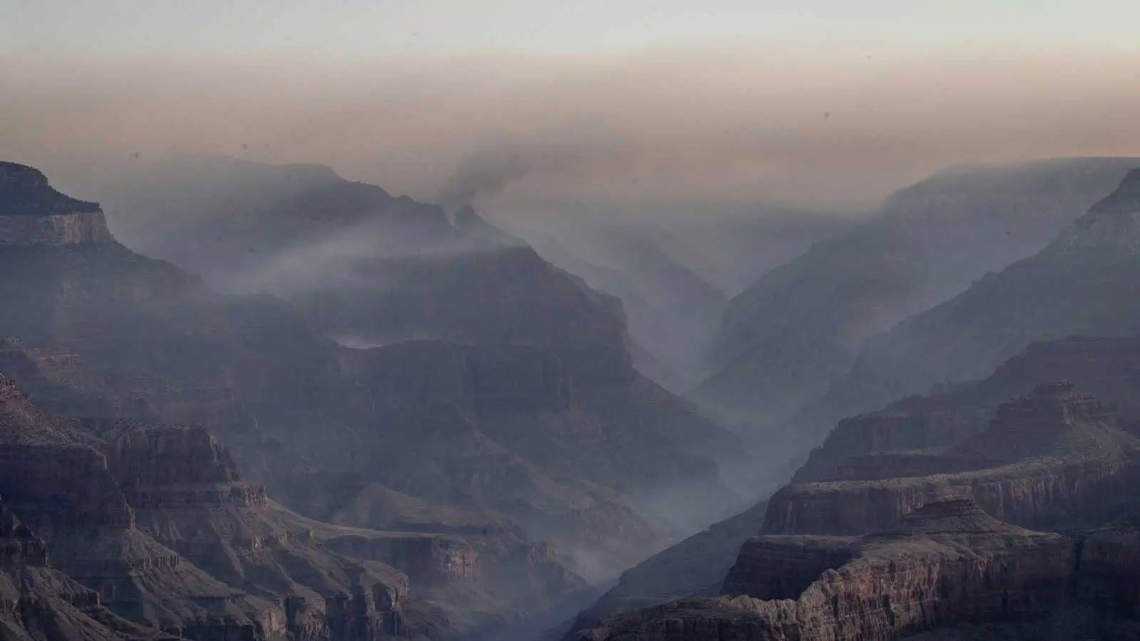
Above: Severe thunderstorms were already erupting across eastern Oklahoma at 1700Z (noon CST) Friday, January 10, 2020. Many more are expected to develop later Friday and Saturday from the Southern Plains into the Southeast. Image credit: RAMMB/CIRA/CSU.
Tornadoes—some strong—are expected Friday and Saturday from Texas to the Southeast, part of an array of threats from a sprawling storm system that will plow across the central and eastern U.S. through the weekend. Feeding into this unusually complex and intense system are moisture amounts at near-record levels for January and winds shrieking at hurricane force less than a mile above the surface.
On Friday morning, the NOAA/NWS Storm Prediction Center placed an area from northeast Texas and southeast Oklahoma to southern Arkansas and northern Louisiana under a moderate risk of severe weather into Saturday morning, surrounded by larger enhanced- and slight-risk areas (see Figure 1). This is a more serious outlook than the term “moderate” might imply. The forecast odds of EF2-or-stronger tornadoes, or thunderstorm winds reaching 74 mph, are at the high end of SPC’s criteria for a moderate risk, which itself is the second highest of SPC’s five risk categories.
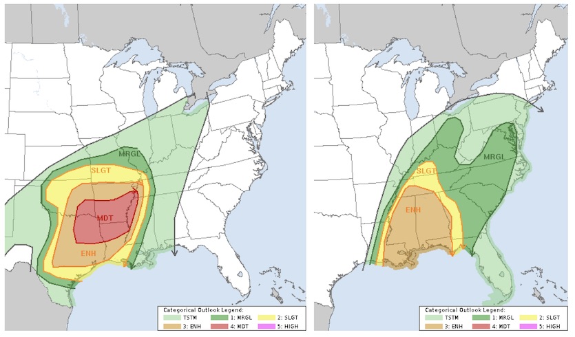
This potential outbreak has been well anticipated. SPC issued its first heads-up with a Day 6 convective outlook issued this past Sunday, January 5, for Friday, January 10—and it covered much of the same area as Friday’s Day 1 outlook.
The fireworks started early on Friday, with a tornado warning in southeast Oklahoma and a tornado watch issued before noon for eastern Oklahoma and far northwest Arkansas. A more concentrated threat will set up later Friday afternoon as a compact, powerful upper-level low angles southeast toward Texas. Ahead of this upper storm, a front will intensify somewhere close to the corridor from San Antonio to Tulsa on Friday afternoon, with a surface low in North Texas. Severe thunderstorms are expected to erupt in these areas by late afternoon, perhaps in the DFW metroplex, and race northeast on Friday evening, soon forming an intense squall line with fierce downburst winds.
Tornadoes will likely be embedded in the squall line, even well after dark. These twisters will be fast-moving (perhaps 50 – 60 mph) and could form and dissipate quickly, making for a very challenging warning situation. On top of this, individual supercell storms may form just east of the low, and any of these could pose an increased chance of spawning strong and/or long-lived tornadoes. Upper-level wind shear is so strong that only modest amounts of instability will be needed to yield rotating storms and tornadoes, and an influx of spring-like air will provide more than enough instability, as temperatures approach or exceed 70°F and dew points rise well into the 60s.
The moisture tap flowing from the Caribbean and Gulf of Mexico into the southeast U.S. is especially impressive. Precipitable water (the amount of moisture in an imaginary column above ground level) will top 1” across much of the eastern U.S., and amounts of 1.5” or more will spread over much of the South. In some locations, this moisture will approach or exceed record levels for any January.
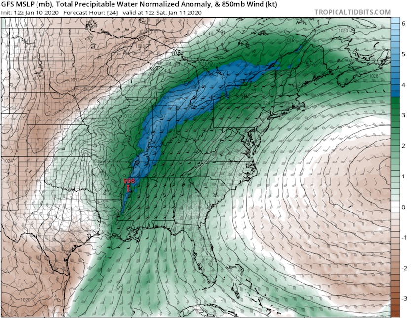
Also noteworthy is the intensity of the low-level jet stream just one to two miles above ground level. From Friday night into midday Saturday, a core of southerly low-level winds in the 80-to-100-mph range will translate across the lower and mid-Mississippi Valley. Some of these winds could mix down to ground level in any of the severe thunderstorms that will move across this area in a sharp squall line overnight into Saturday morning. The shrieking low-level winds will also lead to dangerous levels of wind shear that could produce strongly rotating storms, especially in any supercells that might develop ahead of the main squall line. (At the jet-stream level, four to eight miles high, winds will be howling even more strongly; they will likely exceed 150 mph over the Midwest and top 200 mph over southeast Canada.)
The exceptionally strong low-level southerlies will push rich Gulf moisture further north than usual for midwinter, stoking a belt of heavy rains from the Southern Plains to northern New England. Localized amounts could top 3”, according to the NOAA/NWS Weather Prediction Center, which has issued a moderate risk of flooding rains. The biggest flash-flood concern is late Friday night along a strip from northeast Texas to southwest Missouri. Soils are not especially wet in this area, WPC noted, adding, “Still, the atmospheric parameters and hi-res model signal point towards exceptionally heavy rain today relative to January standards.”

Along the northwest side of this massive storm, a corridor of snow and ice will cause other trouble. Some parts of northeast Oklahoma could see accumulating snow just hours after severe weather. The heaviest snow is expected from the Kansas City area to northern Michigan. Near-blizzard conditions could develop in some areas.
Sleet and freezing rain may develop just to the south of this band, especially from northern Illinois and southern Wisconsin across parts of Michigan and onward to southern Ontario and Quebec (perhaps including Toronto and/or Montreal), northernmost New York, and northern New England. The unusually rich moisture flowing atop shallow surface cold air raises the possibility that some locations from Michigan to southeast Canada and northern New England will get hit with potentially crippling ice. High winds will add stress to any iced-over trees and power lines. A great deal will depend on subtle features (such as the depth of below-freezing layers near or just above the surface) that cannot be called with precision very far in advance.
Along the northernmost belt of rain and freezing rain, widespread minor to moderate river flooding is expected, with major flooding in some areas. According to NWS/Grand Rapids, potential precipitation totals in southern Michigan of 3” to 4” (including rain as well as the water from any melted snow or sleet) could rival a storm system from February 20, 2018, as the heaviest in the region’s history for any winter month (December through February).
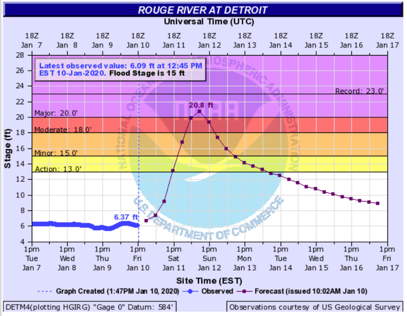
Major flooding is predicted in the Detroit area, where 3” of rain is predicted to fall on top of frozen soils, which will exacerbate runoff. The all-time Detroit calendar day record precipitation amount for January is 1.76” (and for any winter month is 2.41", set in Feb. 1876), so the rains from this storm are likely to cause unprecedented January flooding. Along the Rouge River in Detroit, Sunday morning’s flood crest is predicted to reach the “major” level, topping out at the second highest level since record-keeping began in the 1950s. Major flooding is also predicted in the western Detroit suburbs, at the Huron River in Hamburg. In Jackson, the Grand River is predicted to tie its all-time record crest, although that would only correspond to “moderate” flooding.
For frequent updates on this rapidly evolving storm, see the weather.com article.
Thanks to Dr. Jeff Masters for providing a Detroit-area perspective for this post.
The Weather Company’s primary journalistic mission is to report on breaking weather news, the environment and the importance of science to our lives. This story does not necessarily represent the position of our parent company, IBM.