New Round of Severe Weather to Sweep from Plains to Mid-Atlantic
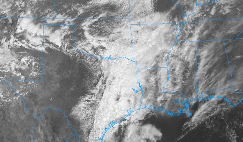
Above: Clouds organize into a gathering center of low pressure in northwest Oklahoma in this visible NOAA GOES-East satellite image from 1751Z (12:51 pm CDT) Wednesday, April 17, 2019. Image credit: College of DuPage NEXLAB.
In the wake of last weekend’s outbreak of severe weather across a wide swath of the U.S., a potent new storm system is taking aim on much the same region. A mix of squall lines and supercells that’s expected to erupt Wednesday evening over the Southern Plains will evolve into a more elongated band of severe storms pushing into the South on Thursday and into the Southeast and mid-Altantic on Friday.
All types of severe weather could occur this week, but the key threats will shift from day to day. As of Wednesday morning, the NOAA/NWS Storm Prediction Center had outlined enhanced-risk areas for all three days (see figures below).
Last weekend’s outbreak produced at least 66 NWS-confirmed tornadoes in 10 states, as tallied by weather.com in a recap article. Two EF3 twisters were reported in Texas, and thirteen EF2 tornadoes occurred across Texas, Mississippi, Ohio, Pennsylvania, and Delaware. The severe weather led to at least nine deaths, dozens of injuries, and close to 100 homes destroyed.
Once again, storms this week will be energized by very strong high-level winds. A powerful upper trough extending along the High Plains on Wednesday morning will dive into the Southeast and form a closed upper low by Friday. On the east side of this feature, winds at the jet-stream level of 250 mb (about 34,000 feet) will be screaming northward at speeds topping 90 knots (105 mph) over the lower Mississippi Valley on Thursday evening and exceeding 110 knots (125 mph) across the mid-Atlantic on Friday night. Meanwhile, at lower levels, south winds will import plenty of warm, moist, and unstable Gulf air.
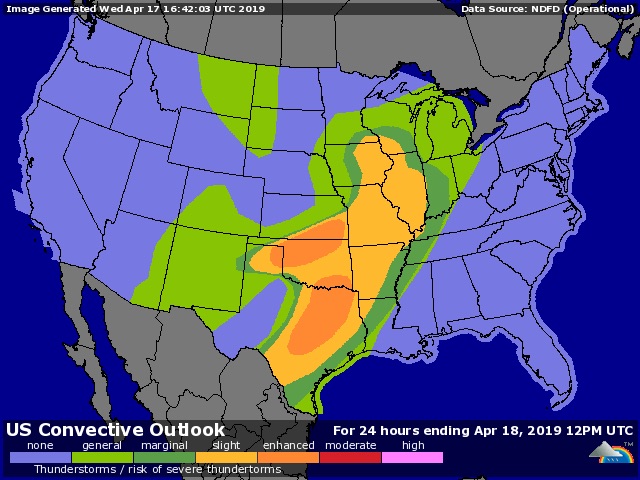
Wednesday’s threat will be centered from Texas to Kansas, where a classic mid-spring pattern is setting up. The NOAA/NWS Storm Prediction Center expects severe weather to be most concentrated in two areas: along a cold front from the Texas Panhandle to southeast Kansas, and along a dry line punching into southern Oklahoma and northern Texas.
Although the upper wind configuration does not favor a widespread tornado outbreak on Wednesday, both areas could produce supercells with one or more tornadoes late Wednesday before the cells merge into more linear structures with a lower tornado risk.
As a result of cold upper-level air and high instability, giant hail—potentially baseball size or larger—is a particular threat on Wednesday with any supercells that form along the dry line. The regions at risk include the Oklahoma City and Dallas-Fort Worth metro areas. Hail is no minor threat from an economic standpoint: several hailstorms affecting large U.S. cities in recent years have racked up damage totals exceeding $1 billion.
Further north, vertical wind shear would support supercells with tornadoes across eastern Iowa, but it appears the surface air may not be warm and moist enough to generate severe storms.
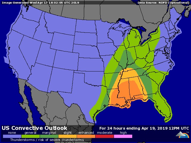
Tornadoes could become a bigger threat on Thursday, as unstable air continues to stream into the lower Mississippi Valley ahead of the advancing cold front and upper low. Vertical wind shear will intensify, and tornadoes (perhaps EF2 or stronger) could form in embedded squall line cells or in any supercells that develop ahead of the main line.
Damaging thunderstorm winds will be another major concern on Thursday, as the strengthening upper-level winds could easily mix down to the surface. The biggest threat areas will be from southeast Louisiana across Mississippi and into Alabama by evening.
Heavy rains are also a safe bet as cells move north along the slowly advancing line. On top of the rainfall from Saturday’s severe weather, the new storms could lead to pockets of flash flooding.
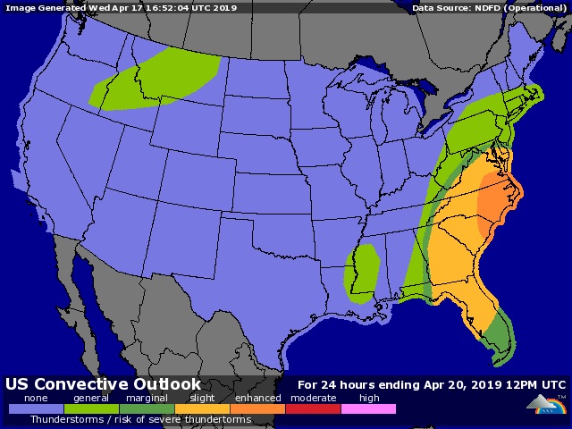
Friday’s severe weather across the Southeast and mid-Atlantic could be widespread, but the peak storm intensities may be dented by warmer air aloft, which will cut down on instability. Even so, the very strong upper-level winds could once again mix to the surface within the regenerating squall line and in any supercells or line segments ahead of it. Tornadoes are not out of the question, especially over and near eastern North Carolina.
After Friday, the next round of severe weather will likely kick into gear late Monday or Tuesday across the Southern Plains. Right now this appears destined to be a more regional event, as opposed to the Plains-to-East Coast outbreaks we've been seeing lately. Jon Erdman has more on this welcome pattern shift at weather.com.
The Weather Company’s primary journalistic mission is to report on breaking weather news, the environment and the importance of science to our lives. This story does not necessarily represent the position of our parent company, IBM.